|
|
|
|
|
|
|
|
|
|
|
|
|
Port Phillip Conservation Council Inc. A0020093K Victoria ABN 46 291 176 191 Founded in 1970 |
||||


|
||||||||||||||
|
Foreshore Strip: Anomalous Status, & Zoning, as FARMING ZONE (FZ), on Mornington Peninsula Planning Scheme Map 1 |
||||||||||||||
|
Click on a blue hyperlink of interest. |
|
|||||||||||||
|
Anomalous Status & Zoning of Foreshore Lot: PPCC Inc. has been concerned about a significant apparent anomaly in the boundary of the Mt Eliza coastal Green Wedge, as shown on Map 1 of the Mornington Peninsula Planning Scheme, which would appear to be the exclusion of a lot that adjoins the north-west corner of the Green Wedge, on its north-east side, as that lot appears on Map 1 as though it could be freehold land, although it is apparently coastal Crown land. This oddity has been explained by the Department of Sustainability and Environment, and the existing Green Wedge boundary - but not the FZ zoning - thus appears to be appropriate. That FZ-zoned land should be rezoned PPRZ and made part of the Mt Eliza Foreshore Reserve.
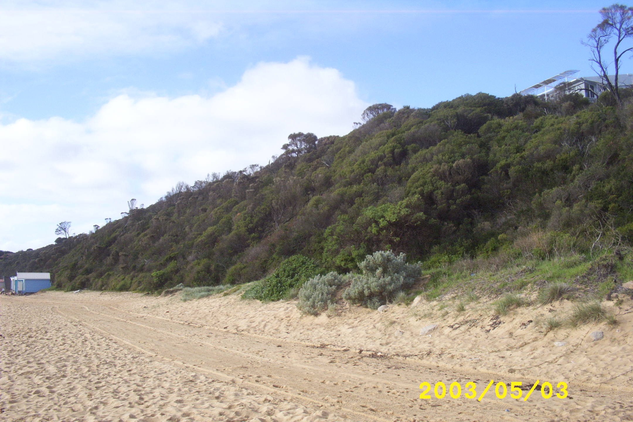
The 0.53 hectare lot that is anomalously zoned ‘Farming Zone’ abuts the Mt Eliza Foreshore Reserve here. PPCC Inc. nevertheless considers that Map 1 of the Mornington Peninsula Planning Scheme should be corrected so that the 0.53 hectare lot described below shown as being zoned Farming Zone (FZ), which had appeared as Rural Zone 3 when PPCC Inc. first raised this matter with the Department of Sustainability and Environment in 2003, should instead be shown as being zoned Public Park and Recreation Zone (PPRZ), as it is now publicly owned and managed foreshore land, like land just inland of the Mt Eliza Foreshore Reserve, which adjoins it on its north-west boundary, should be extended to cover the lot in question, and is shown as having that PPRZ zoning. The Schedule to the Farming Zone in the Planning Scheme reads very oddly in relation to this lot. The lot of concern is of an irregular quadrilateral shape of 0.53 hectare (1.325 acre) on the south-west corner of the junction of Sturio Parade and Osprey Avenue, Mt Eliza (Melway 105B2), which apparently has as its title boundaries: NORTH-WEST: c. 60 metres of the high
water mark of Port Phillip This lot is left zoned Farming Zone (FZ) on Map 1 of the Mornington Peninsula Planning Scheme, but detailed advice that PPCC Inc. has obtained from the Department of Sustainability and Environment in June 2003 is that the land was transferred to the Crown on 20th October 1980 (Crown Land Designation P241639) and was, by an Order-in-Council of 20th October 1980, temporarily reserved for public purposes under Section 5(1) of the Crown Land (Reserves) Act 1978 as Reserve RS12319. DSE said that the [predecessor of the] Mornington Peninsula Shire Council [the then Shire of Mornington] was appointed Committee of Management on 22nd August 1983. This lot is anomalous in that it is an isolated, stranded tiny piece of land with a Farming Zoning (FZ) yet about half of it includes a public beach to the water's edge. The other half includes a steep cliff covered with indigenous vegetation that is similar to what has been detailed in an ecologist's report on nearby public land, and it is in good condition except at its upper south-eastern boundary with residential land, where intrusion of exotic species has been allowed to take place. PPCC Inc. considers that this 0.53 hectare lot should be proclaimed as being permanently reserved under the Crown Lands (Reserves) Act 1978, as is the case with the Mt Eliza Foreshore Reserve, which abuts it on the north-east, and that it should be added to that Reserve and be shown on Map 1 with the same PPRZ zoning as that Reserve. Osprey Avenue to Sunnyside Road - Need for Permanent Public Foreshore Reserve Status, & Zoning: Map 1 of the Mornington Peninsula Planning Scheme shows a strip of foreshore land delineated between the seaward prolongation of Osprey Avenue (Melway 105B2) and a similar prolongation of Sunnyside Road, Mt Eliza, (Melway 104K5). That strip of land, shown in a 1998 aerial photograph on this Web site, is shown as being zoned Farming Zone (FZ) on Map 1, even though the foreshore land at each end of it is shown as being zoned Public Park and Recreation Zone (PPRZ). Documentary evidence exists of the publication, in an 1873 issue of the Victoria Government Gazette, of an Order-in-Council proclaiming that foreshore strip, including the beach, as a Permanent Public Recreation Reserve (Reserve 5207), but it appears, from the present absence of such a reserve there, that unfortunately the Order-in-Council must have been revoked at some later date, as yet unknown to PPCC Inc. It is pleasing, particularly in the light of PPCC Inc. Policy Statement No. 12, "Remnant Large Open Space Land Parcels in Port Phillip Catchment Area", that this strip, with the exception of the 0.53 hectare lot above, is protected at least by being within a Green Wedge under Part 3AA, "Metropolitan Green Wedge Protection", of the Planning and Environment Act 1987, as it is shown on Map 1 of the Mornington Peninsula Planning Scheme as being within the bold blue border lines of the Green Wedge urban growth limits. PPCC Inc. considers that this strip of land, the seaward half of which is mostly a sandy swimming beach in regular unchallenged public use and the landward half of which is a fairly erodable cliff with good indigenous vegetation, but currently marred by a presently necessary yet nevertheless unsightly and damaging electric fence line, which would be better located further inland out of sight from the beach, should not have a rural zoning, with no plausible rural context or use whatsoever, but should be shown on Map 1 as being zoned Public Park and Recreation Zone (PPRZ), consistent with the similar foreshore strip at each end of it. |
|
This page was last updated on 2011-10-09.