|
|
PORT PHILLIP Newsletter of Port Phillip Conservation Council Inc. |
|
|
A0020093K |
PP2006A April 2006 www.vicnet.net.au/~phillip |
|
|
|
|
|

|
Call
for a Referendum on Channel Deepening with the 2006 Elections |
|
Port Phillip Conservation
Council Inc. has written to the Premier of Victoria, Hon. Steve Bracks MLA,
requesting that a binding referendum be held in conjunction with the next
State election to seek the approval or otherwise of the voters of Victoria on
allowing any further deepening of the shipping channels through important
parts of The Rip, Port Phillip and Yarra River. Of the two major parties,
one - the Australian Labor Party - supports the channel deepening proposal.
The other - the Liberal Party - snipes, but fails to propose any alternative
policy. This dilemma leaves a specific vote on this major issue as the only
way to determine the majority viewpoint of Victorians on it. Mr. Bracks wrote back to
Port Phillip Conservation Council Inc. saying, “… While the requirement
for referenda to be held in Port Phillip Conservation
Council Inc. replied to the Premier asking, as a matter of urgency, that the
Government introduce a bill to provide for binding referenda, and that the channel
deepening issue should be subject to such a vote in conjunction with the
State elections to be held on The bill should be such
that the resulting Act, and the legal effect of the result of any referendum
decided under it, should be entrenched, with a special majority vote in
Parliament, or a further referendum applying to its repeal or amendment, as
applies to the Acts Mr Bracks cited. The wording of a referendum
question held inexpensively at the same time as the elections in November
2006 could ask voters to decide whether further deepening of the shipping
channels in The Rip, Port Phillip, or the lower Yarra River should be made
lawful, or be made unlawful. We also reminded the
Premier that as his Government controls both houses of the Parliament, and as
it surely has full faith and confidence in |
|
|
|
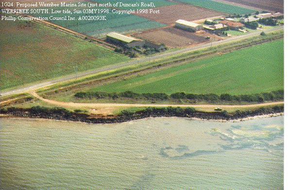
Independent Panel Hearing: Planned 27
hectare marina at Werribee South |
|
|
|
Since the early 1980s a large marina in Port Phillip at |
|
|
|
|
|
|
|
Site of Proposed
|
|
|
|
The Minister’s ruling
was in response to a proposal by Wyndham Cove Marina Pty. Ltd. for a permit
to build a marina
at Werribee South, which would cover 27 hectares (67 acres) of the waters
of Port Phillip. That area of sea and seabed would be almost fully enclosed
by a high sea wall of boulders 1 kilometre long. In addition to that impact, the developer seeks approval for a 5-storey and other associated buildings on the coast, including a restaurant, shops and service buildings, as well as a 200-dwelling residential development adjoining the marina structures and their associated car parks. An Independent Panel was set up to evaluate the EES and a
related proposed Amendment C071 to the Wyndham Planning Scheme,
which would be needed for the development to be approved. Port Phillip
Conservation Council Inc. made a written submission on this proposal, and
also had a representative put its case at a hearing of the Independent Panel
in December 2005. Under the heading “EES
is a Shameless Apologia Extolling a Fantasy and Caring Little for Existing
Values”, PPCC Inc.’s submission to the Panel stressed its
view that it was a complete fantasy that the imposition of such a massive
industrial and commercial complex on the quiet, rural coastal atmosphere and
Green Wedge ambience of the land, and the intrusion of a kilometre length of
rock wall in and above the waters of Port Phillip, could have other than a
massively detrimental effect on the existing environment of this coastline. It seems sad and
unrealistic to read in the EES of users of the Bay Trail from Point Cook to
Werribee for walking and cycling being confronted on their entire approach
with the prospect of a 5-storey building looming up, a kilometre long pile of
boulders out in the Bay, and a mini-suburb to thread their way through. Melways Page 209 shows Duncan’s
and Beach Roads, Werribee South, marked as TOURIST ROADS. The 200 dwellings -
the economic motive for this proposal - are completely inconsistent with a
Green Wedge zoning they prevent from reaching the coast so it can meet there
what should be left as a Blue Wedge of open sea and open sky. The extravagant spin in the
Environment Effects Statement begins at the artist’s drawing of a
Coliseum-like structure with nearby lakes and lush green vegetation
everywhere, apart from the proposed suburban enclave many kilometres from
urban facilities – all of this water and lushness in Werribee’s
pronounced rain shadow zone. PPCC Inc. recommends that
the proponent’s EES be seen as focusing almost entirely on a
hypothetical replacement environment, and avoids acknowledging that the
commercial and quasi-industrial complex that would be created if the scheme
succeeded would utterly dominate the natural and modest coastal environment
now existing, which is agreeable, restful and affordable to all. The EES process unfortunately
does not include comparisons with a more benign alternative scenario in which
the public sector could plan and create, using existing land and further land
publicly acquired, a fine coastal park that would cater to the future larger
population expected on the large areas further inland, saving the coastline
from the inevitably damaging residential, commercial and quasi-industrial
blight faced. The low, flat, basaltic western coastline of Port Phillip should have been better treated in the past, and protected by a wider foreshore reserve, but the proper response by authorities is to identify its longer term timeless values and work to preserve, protect and defend them rather than to sanction opportunistic proposals for profit likely to obliterate the possibility of conserving and restoring those values. Good examples of that approach on Port Phillip’s west coast are the Point Gellibrand Heritage Coastal Park, and the rehabilitation of the former municipal tip at Altona Meadows near the mouth of the Laverton Creek. |
|
|
|
Aftermath of the Do-it-Yourself Canal and Groynes at Leopold |
|
|
|
The fate of the illegal
unfinished would-be marina on seafront land at Leopold, which was brought to
the attention of the Department of Sustainability and Environment and Greater
Geelong City Council in 2005 (see PP2005B),
is slowly being resolved. The DSE has told Port
Phillip Conservation Council Inc. it is satisfied that the majority of the
works stated in the interim enforcement order have been undertaken by the
owners, except for the design and narrowing of the drainage outlet to Corio
Bay to just a drainage channel. Through their consultants, the landowners are
co-operating with Greater Geelong City Council and DSE. Issues being dealt with
include drainage management within and outside the property, quality of water
retained on the property and discharged into The Department also noted
that VCAT has yet to hear and determine applications for costs, and Greater
Geelong City Council’s application for an enforcement order. PPCC Inc. considers that
there should be a significant width of Crown land reserve between high tide
and any freehold land. To make a lasting contribution to the area so wilfully
damaged, a penalty imposed on the owners, D&H More, should be their being
required to pay the Government much, or all, of the cost of its compulsorily
acquiring sufficient land to create such a reserve, similar to those around
most of the coastline of Port Phillip. |
|
|
|
© 2006 Port Phillip Conservation Council Inc. President: Len Warfe Secretary: Jennifer Warfe Tel: (03) 5987 1583 Fax: (03) 5987 2537 |