|
|
|
|
|
|


|
Port
Phillip Conservation Council Inc. A0020093K
|
|
|
|
Port Phillip
named for Captain Arthur Phillip R.N. -
Proclamation as a British Possession |
|
|
|
Formal possession, on behalf of the British Crown, of the whole of the eastern part of the Australian continent and Tasmania was not taken until 26th January 1788, when the Commission, first issued to Captain Arthur Phillip, a Captain in the Royal Navy, on behalf of King George the Third by the Viscount Sydney, the British Home Secretary, on 12th October 1786 and amplified on 2nd April 1787, was read to the people whom he had brought with him in the "First Fleet". The Commission appointed Phillip "Captain-General
and Governor-in-Chief in and over Our
territory called New South Wales,
extending from the Northern Cape or
extremity of the coast called Cape
York, in the latitude of ten degrees
thirty-seven minutes south, to the
southern extremity of the said
territory of New South Wales or South
Cape, in the latitude of forty-three
degrees thirty-nine minutes south and
of all the country inland westward as
far as the one hundred and
thirty-fifth degree of east longitude
reckoning from the meridian of
Greenwich, including all the islands
adjacent in the Pacific Ocean within
the latitudes aforesaid of ten degrees
thirty-seven minutes south and
forty-three degrees thirty-nine
minutes south". The above statement is derived from an
account on Page 2 of the Official
Year Book of the
Captain Cook's claim, made 17 years earlier than Governor Phillip's proclamation, had as its southern limit the latitude of 38 degrees south and had thus not included any part of Port Phillip Bay, its coastline or hinterland south of a line between a point a little south of Table Rock Point, Beaumaris, and Kirk Point, Avalon. Captain Cook specified 38 degrees south because that was the latitude of the point where he first sighted the coast of the Australian continent, and he sailed north along the coast from that point, which he named Point Hicks, after the officer on his ship that had first sighted the Australian continent. |
|
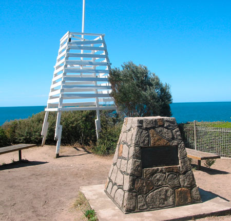
A plaque on the monument at Point King, Sorrento, Victoria (Melway 157A3), records the raising there of the Union Jack flag (used to mark possession of territory by the British Crown for the first time in Australia in its current modern form including St Patrick's cross, as shown above), and the Proclamation there, by Lieutenant John Murray RN, on 8th March 1802, of the British possession of Port King, named after the then Governor of New South Wales, Captain Philip King, as a Port, in the name of King George III. Port King was later officially renamed Port Phillip, after the first Governor of New South Wales, Captain Arthur Phillip. |
|
|
|
Click here
for an account of the visit to Port Phillip
by Lieutenant Matthew Flinders RN in April
1802 as part of his circumnavigation of the
continent of |
|
|
|
Click here for details of the short-lived first British settlement at Port Phillip, in October 1803, which was led by Lieutenant-Governor David Collins. |
|
Before the British occupation of the Port Phillip District, which was the name used for the area that later became the Colony, and then the State, of Victoria, the land around Port Phillip was occupied, for what is believed to have been over forty thousand years, solely by aboriginal people, of whom there were relatively few, compared with the flood of British settlers that subsequently arrived. The scale of environmental degradation during that period of sole occupation by small numbers of aboriginal people was very small. Significant degradation has occurred since then, and is still occurring. Recent governments of Victoria have nevertheless had a policy to encourage further increase in the population of Victoria. The history of the descendants of those original occupiers has not been a fortunate one. |
|
*
* * * * * * * * * * |
|
Last
updated on 2012-11-30
|
